Pict. [Mapporn] Geological Map of the Black Hills from 1879 - Henry Newton, E.M. for the USGS [6305x4363] (#Black #Map #Geological #Usgs #Newton)Pict. 3153×2182 px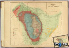 Pict. [Dataisbeautiful] USGS 8.0+ earthquakes since 1900, with the bubbles linearly proportional to the number of fatalities (#Number #Bubbles #Proportional #Usgs #Linearly)Pict. 2000×2000 px
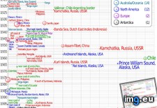 GIF [Mapporn] Colorado River path changing at Hite Marina (Lake Powell). [454 x 654][GIF] Images from USGS. (#Gif #Images #Lake #River #Powell #Usgs #Hite)GIF 454×654 px
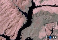
★ 5681 pkt. ♥ 0 gefällt ⬇ 2 gespeichert
Pict. [Dataisbeautiful] USGS 8.0+ earthquakes since 1900, with the bubbles linearly proportional to the number of fatalities (#Number #Bubbles #Proportional #Usgs #Linearly)Pict. 2000×2000 px★ 4800 pkt. ♥ 0 gefällt ⬇ 5 gespeichert
GIF [Mapporn] Colorado River path changing at Hite Marina (Lake Powell). [454 x 654][GIF] Images from USGS. (#Gif #Images #Lake #River #Powell #Usgs #Hite)GIF 454×654 px★ 7671 pkt. ♥ 0 gefällt ⬇ 7 gespeichert